Thursday 27 August 2015

Cylindrical Structures in Potsdam Group Sandstone in Eastern Ontario - Part 2

My blog posting from January 29, 2014 provided an introduction to cylindrical structures found in Potsdam Group sandstone of Eastern Ontario, provided historical photographs of the Park of Pillars at the Hughes Quarry on the east bank of the Cataraqui River four miles above the locks at Kingston Mills, canvassed the theories on the origins of the cylindrical structures and listed a few of the locations in Eastern Ontario where the cylindrical structures can be found.


Cylindrical Structures at the Park of Pillars at the Hughes Quarry


This month provided an opportunity for me to visit the Park of Pillars at the Hughes Quarry.   When I learned that the Niagara Peninsula Geological Society had organized a two day field trip to Eastern Ontario, with a stop on Sunday, August 16 scheduled for the Park of Pillars, I had to go.  I joined the Niagara Peninsula Geological Society and signed up for the field trip.  I was glad that I did as it was a very enjoyable field trip.   I don’t know if I’ve ever been on field trip with people so enthusiastic about rocks.

Below are three photos taken at the Park of Pillars.  The gentleman that is the scale in the first photo is a little over six feet tall and is holding a meter stick.   The second photo shows the concentric rings visible on the underside of the cylindrical structure shown in the first photo.   The third photo shows a much larger cylindrical structure about ten feet to the left of the first structure.   My photos show the same cylindrical structures figured in the historical references mentioned  and reproduced in my earlier blog posting.


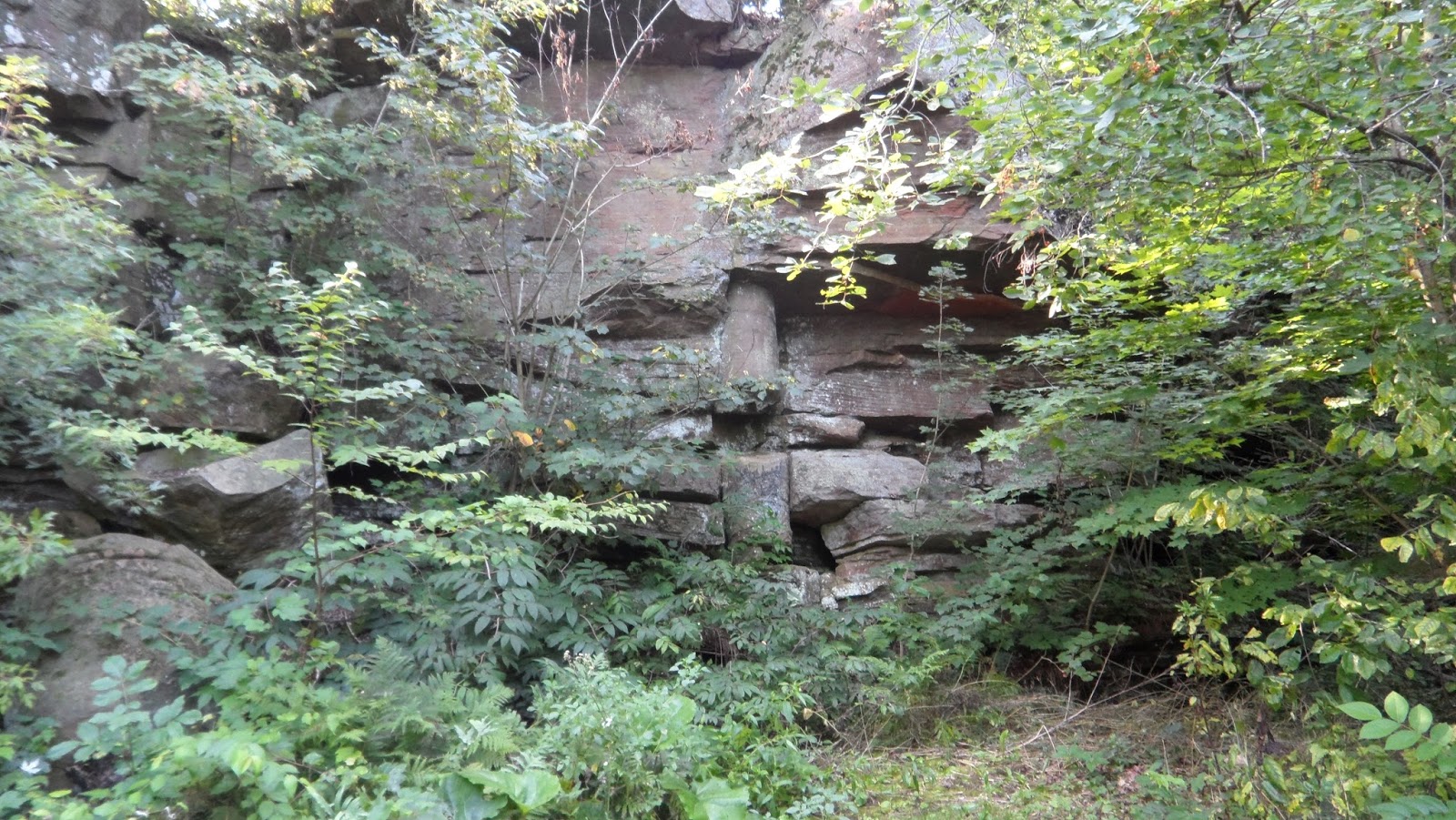
Dave Forsyth of Arnprior was our guide.  Dave pointed out that the alteration extends beyond the cylinders into the surrounding rock and does not end at the fractures that define the cylinders.

An Occurrence 4.5 kilometers South of Elgin


My earlier blog posting  mentioned a few of the locations in Eastern Ontario where the cylindrical structures can be found.    One additional location that is worth mentioning is referenced by Sanford and Arnott (2010):

“A similar but much smaller columnar structure was found in the Chippewa Bay Member of the Covey Hill Formation [of the Potsdam Group Sandstone] at station O-30 approximately 4.5 km southeast of Elgin, Ontario (Fig. 42.a, b).”

[B.V.  Sanford and R.W.C. Arnott (2010), Stratigraphic and structural framework of the Potsdam Group in eastern Ontario, western Quebec and northern New York State, GSC Bulletin 597, at page 43] 

Sanford and Arnott’s description of the two photos that are Figure 42 is as follows:  

“Figure 42.  Miniature cylindrical column in the Covey Hill Formation (Chippewa Bay Member), 45. Km southeast of Elgin, Ontario at station O-30.  a) Plan view of the small columnar structure...b) Partially exposed cross-sectional view of the column.”

This past weekend while returning from an auction I decided to look south of Elgin for cylindrical structures.   While I didn’t find the outcrop that appears in Sanford and Arnott’s publication  (I  must have been very close to their outcrop as I would plot my outcrop on the map that accompanies their report in the identical location as their station O-30), I  found an outcrop which shows numerous circular and concentric structures weathering out of sandstone.    Below are four of the photographs that I took.


The circular and concentric structures that I found are generally in the range of 5 to 18 cm (2 to 7 inches) in diameter.  I believe these circular and concentric structures to be cross-sections of numerous small, cylindrical structures.

The outcrop is a horizontal, glacially polished, surface of off-white sandstone.  It is  about the size of half a soccer pitch, a third of which exhibits circular and concentric structures.  I didn’t count the circular and concentric structures but there had to have been  over two hundred of them.

While I believe these circular and  concentric structures to be  cross-sections of cylinders, they could represent cross-sections through spherical concretions or cones.   Both rounded concretions and conical (funnel shaped) structures  have been reported in the Potsdam sandstones.

Dr. R. W. Ells of the Geological Survey of Canada was probably the first to report on rounded concretions in the Potsdam sandstone in Canada  when discussing the cylindrical structures at Gildersleeve’s Quarry,  now referred to as Hughes Quarry:

“In the quarry several curious cylindrical concretions occur which resemble the trunks of fossil trees, and at one time they were regarded as such.  They stand upright in the face of the quarry, the two principal ones having diameters of three and four feet, with an outer zone of three inches or more in concentric layers, corresponding to what would have been the bark if the structures had been organic....Numerous rounded concretions, from half an inch to two inches in diameter are found in the vicinity of the supposed trees, which by some persons have been regarded as the fruit.  Rounded concretions of this kind are found in similar sandstones at the southern end of Knowlton lake.”

[Ells, R.W., 1905, The District Around Kingston, Ontario, Annual Report (New Series) for 1901, Volume XIV, Geological Survey of Canada, Report A, at page 176A]
   
A recent reference to a conical structure in Potsdam sandstone is that “an example of an upward expanding (funnel shaped) cone is observed on Jones Falls Road, Ontario, 2.5 km west of Highway 15, at station O-29" (B.V.  Sanford and R.W.C. Arnott (2010), at page 41).

Round concretions and conical structures have also been reported with the vertical cylinders in the Potsdam sandstone in Jefferson and St. Lawrence counties, New York (Hough, 1850; Dietrich, 1953).   Hough reported on vertical cylinders, associated conical structures, and associated spheroidal structures that were “seldom larger than an orange, usually occurring together in great numbers.  When broken they present a perfect concentric stratification....” [Hough, Franklin B., 1851, On the Cylindrical Structure Observed in Potsdam Sandstone,  Proceedings of the American Association for the Advancement of Science, Volume 4, pages 352-354]

Dietrich  reported that  “Two cylindrical structures, one inverted conical structure and seven structures having circular horizontal sections and vertical sections of unknown shapes occur in the Upper Cambrian Potsdam sandstone two miles north of Redwood, New York.” [[Dietrich, R.V. (1953), Conical and Cylindrical structures in the Potsdam Sandstone, Redwood, New York, New York State Museum Circular 34, at page 1]  He found a cylinder 15 feet in diameter and more than 9 feet in length, a cylinder 15 inches in diameter and more than four feet in length, and seven circular horizontal sections with diameters ranging from 2 inches to three and a half feet.

References to Cylindrical Structures found in Lanark County


I have not yet found an outcrop in Lanark County showing cylindrical structures in sandstone, but have noted that part of a sandstone cylinder is on display at the Perth museum and have found additional references to them as having been found in Lanark.   (I say “additional” because my earlier posting mentioned  specimens from Almonte in McGill’s collection  that were referred to by Dawson (1890).)

Not surprisingly, the first reference refers to Doctor James Wilson of Perth:

“In the sandstones near Perth the late Dr. Wilson, nearly thirty years ago, found a number of long cylindrical casts like tree trunks from six inches to one foot in diameter.   Last year attention was called to certain cylindrical bodies of larger size than the above which pass almost at right angles through the sandstone beds of this formation near the Rideau canal about eight miles from Kingston.”

[Report of the Royal Commission Upon the Mineral Resources of Ontario and Measures for their Development, 1890, Toronto, Warwick & Sons, at page 40]

I’ve also noted that  Jean Dugas, who provided the marginal notes to geological  Map 1089A, mentions that cylindrical or conical structures can be found in North Elmsley Township,  Lanark County.   She commented:

“Peculiar bands showing cylindrical or conical structures noted in the Nepean formation, and best observed on lot 24, Con. VI, North Elmsley tp., are the same composition as the surrounding sandstone , but cut sharply across the beds and are themselves bedded parallel with the walls of the structures.  They are probably formed by slumping of the sand due to water structures.”

[M.E. Wilson and Jean Dugas, 1961, Map 1089A, Geology, Perth, Lanark and Leeds Counties, Ontario, Geological Survey of Canada, Geology by M. E. Wilson, 1930 and Jean Dugas, 1949, Descriptive notes by Jean Dugas.]
                   
Lot 24 of Concession VI in North Elmsley Township is 2 km west of Rideau Ferry and lies south of County Road 1.  

I have not been able to find Wilson and Dugas’ occurrence in Lot 24 of Concession VI in North Elmsley Township.  Wilson and Dugas’ map shows only two outcrops on that lot.  I found one of their outcrops.   It is about 4 feet high and over 30 yards long and is now part of the front lawns of three houses on West Point Drive that back onto Big Rideau Lake.   Crossbedding is visible, but no cylindrical structures could be found on the vertical face of the outcrop. Unfortunately, landscaping (topsoil and grass) has obliterated the top of the outcrop.

In an earlier blog posting discussing Perthite I mentioned that  Jean Dugas had presented her doctorate thesis on the rocks of this area  (Dugas, Jean, 1952, Geology of the Perth map area, Lanark and Leeds Counties, Ontario; Ph. D., McGill).   Unfortunately it is not possible for me to check her thesis to confirm the lot and concession number as her thesis has not been digitized and made available online.

In the early 1980's the Ontario Geological Survey re-mapped the Paleozoic rocks in Eastern Ontario.   Williams and Wolf, who mapped the Perth area,  reported that  “cylindrical structures have been reported by Wilson and Dugas (1961)” [Williams, D.A. and Wolf, R.R., 1984, Paleozoic Geology of the Perth Area, Southern Ontario; Ontario Geological Survey, Map P.2724, Geological Series -Preliminary Map. Scale 1:50,000. Geology, 1982].  However, they did not report finding cylindrical structures.   Further, Williams and Wolf ‘s  Map P.2724 shows no outcrop in Lot 24 of Concession VI in North Elmsley Township.

Additional References to Cylindrical and Conical Structures in Sandstone in Eastern Ontario


My blog posting from January 29, 2014 listed a few of the locations in Eastern Ontario where cylindrical structures can be found in Potsdam sandstone.   Here are additional locations:

1)  2 km north of Morton, roadcut off Highway 15


“Crossbedding is common, and unique cylindrical structures or “pillars” (Dietrich 1953) were observed in a roadcut along Highway 15, 2 km north of Morton.”
[Williams, D.A. and Wolf, R.R. 1984, Paleozoic Geology of the Westport Area, Southern Ontario; Ontario Geological Survey, Map P.2723, Geological Series -Preliminary Map. Scale 1:50,000. Geology, 1982, in marginal notes]
“Sandstone pillars have been reported in the Perth area by Wilson and Dugas (1961), and were observed at several localities in the Westport map area (31C/0).  Excellent examples are present in the Highway 15 roadcut 2 km north of Morton (UTM 404120E, 4934250N) (Plate 4).”
Plate 4 is a photograph of the “Cylindrical structure in quartz sandstone of the Nepean Formation, Highway 15 roadcut 2 km north of Morton”.
[Williams, D.A., 1991, Paleozoic Geology of the Ottawa-St. Lawrence Lowland, Southern Ontario; Ontario Geological Survey, Open File Report 5770, 292 pages, at pages 44 and 41.]


2)  Washburn Road, west of Highway 15 and close to Rideau Canal


Source: personal communication, Dave Forsyth, 2015.
   

3)  Along southern Melville Island in St. Lawrence River


“A thicker section of sandstone beds is found in a block along southern Melville Island (Fig. 16),  The exposed face displays crossbedding at several levels within the concave-up beds that may be the foreset beds within a large subaqueous dune.  The lower image details conglomerate beds, crossbedding and an eroded section of a dewatering structure.”   “Fig. 16. Sandstone block with conglomerate and cross-beds; dewatering cylinder at right edge of block.”
[Al Donaldson, Dave Forsyth, Chris Findlay and Bud Andress, 2010,
Fall Geology/Ecology Boat Tour - St. Lawrence River  1000  Islands, at page 20
http://www.frontenacarchbiosphere.ca/explore/fab-education/geology/st-lawrence-river-thousand-islands-geology-boat-tour ]

4) South March Highlands, Kanata


The South March Highlands border Kanata and are south of March Road, east of Huntmar, west of March Road and north of Terry Fox Drive.  A Photo with the legend “unequivocal dewatering cylinders preserved in Paleozoic sandstone - An Ancient Spring.” appears at page 14 in a 49 page presentation (in pdf format) entitled “Ottawa’s Great Forest: The South March Highlands” prepared by Carp River Conservation Inc. that can be downloaded from 
http://www.renaud.ca/public/Presentations/2011-05-17%20SMH%20Overview%20v17.pdf   


5) On Huckleberry Island in the St. Lawrence River near Gananoque, Ontario

   
A photo of this cylindrical structure is Plate 124, which appears between  pages 1030 and 1031,  in

J. E. Hawley and R. C. Hart, 1933
Cylindrical Structures in Sandstone, Bulletin of the Geological Society of America, Volume 44, pages 1017-1034
    

6) Near Westport, Ontario


Source:  J. E. Hawley and R. C. Hart , 1933, at page 1020.       

7) Jones Falls


Sanford and Arnott report that “an example of an upward expanding (funnel-shaped) cone is observed at Jones Falls  Road, 2.5 km west of Highway 15, at Station O-29 .”

B.V. Sanford and R.W.C. Arnott, 2010,
Stratigraphic and structural framework of the Potsdam Group in eastern Ontario, western Quebec, and northern New York State; Geological Survey of Canada, Bulletin 597


Christopher Brett
Perth, Ontario


Tuesday 18 August 2015

If there's something strange in your neighborhood, who you gonna call?

 
Those that watched movies in the mid-1980's or had kids who watched television in the late 1980's will instantly recognize the title of this posting as the first line of the theme song for the movie Ghostbusters,  a 1984 comedy film starring Bill Murray,  Dan Aykroyd and Harold Ramis as three parapsychologists who start a ghost-catching business in New York City, with Sigourney Weaver as their most important client and Rick Moranis as her neighbor.   It was also the theme song for The Real Ghostbusters, an animated television series, a spinoff of the 1984 movie, that ran from 1986 to 1991. 

The question posed by the song title “If there's something strange in your neighborhood, who you gonna call?” seems to apply to the following three specimens that were recently quarried from Potsdam sandstone north of Kingston.   These strange specimens  were shown to me on Sunday by Jimmy Jackson, the owner of Rideauview Contracts, which operates a number of quarries in Eastern Ontario, including the sandstone quarry at Ellisville, Ontario

Jimmy Jackson had a lot of fun with the specimens.   The first he called “the Wolf” and the second, “an insole, size 11.”    I have to admit that I’ve never  seen anything like these specimens.

Specimen 1 - The Wolf


The first specimen has white sandstone arguably taking the shape of a wolf on the vertical surface of a block of  red sandstone,  and was collected because of that image.


When split horizontally it shows white sandstone taking various rounded, globular shapes in the red sandstone.


Specimen 2


A second similar specimen, also split horizontally (and partially wetted by Jimmy to enhance the contrast in colours), shows  similar rounded, globular shapes.


The next photo is a side view of part of the second specimen.


The first two specimens, each of which is in two parts,  were quarried from the same beds that produced  specimen 7 on my July 16, 2015 posting and specimens 1 and 2  on my June 30, 2015 posting.  I believe the beds to be the Hannawa Falls Member of the Covey Hill Formation of the Potsdam Group. 

When asked by Jimmy to provide an explanation for the shape I had to admit that I couldn’t answer his question.   On further reflection I suspect that it could be an example of chemical precipitation (leisegang banding  is present at other spots in the quarry, and a number of cylindrical dewatering structures have been found within 30 meters of these beds).   However, as the white sandstone is the colour of the overlying sandstone I suspect that it is more likely that cavities developed in the red sandstone beds that were filled in with the white sandstone.  This of course raises the question “What caused the cavities?”   Was it water percolating through the ground or burrowing?


Specimen 3 - Insole, Size 11


I suspect that there is a more scientific way to describe this shape, but Jimmy’s description of a size 11 insole is probably the most apt.  

This specimen I believe to be an example of chemical precipitation ( and it looks like banding   present at other spots in the quarry). 

I had thought about contacting another geologist for a second opinion, and adding his name in the title of the blog after the question “If there's something strange, in your neighbourhood,
Who you gonna call?”    On further reflection I realized this would be a mistake.  First, you wouldn’t believe how hard it is to find a paleontologist or geologist with a name that has the same number of syllables as the word “Ghostbusters” with a strong first syllable.   Second, I realized that this person would have to have a sense of humour, and wouldn’t mind being tagged with the Ghostbusters theme song.

Christopher Brett
Perth, Ontario

I ain't afraid of no ghost.   I ain't afraid of no ghost.

++++++++++++++++++++++++++++++++++

Added August 20th:
I received the following helpful comment:
“Hi, Christopher--I've been enjoying your blog posts!
I suspect the first two specimens are reduction halos, similar to those seen here: http://www.southampton.ac.uk/~imw/Budleigh-Salterton.htm (scroll down to about halfway down the long page). I've seen examples in many red iron-stained rocks. I'd concur with your interpretation of "specimen 3", mineral banding ("liesegang").
--Howard Allen”

I’ve had a look at the photos on the web page that Howard Allen referenced and agree with him that the photos on my blog could show a similar feature.   The web site at the link he provides mentions that  the “the reduction features are locally associated with dark grey radioactive nodules that contain high proportions of metallic elements including vanadium, uranium, copper and nickel”.   There are concentrations of  minerals at the centers of the globular features in my photos, which could we worth investigating.  

That web site also references the paper: Bateson, J.H. and Johnson, C.C. 1992. Reduction and related phenomena in the New Red Sandstone of south-west England. British Geological Survey Technical Report, WP/92/1 , which can be downloaded from http://nora.nerc.ac.uk/509450/

Bateson and Johnson mention:
“Hofmann (1991) in his study concludes that the weight of evidence from a wide variety of locations, geological environments and ages, points towards a genesis for the reduction phenomena and accumulation of exotic elements that assumes a supply of porewater containing both the reductants and exotica (p 121). The localisation of the reduction spots, according to Hofmann's hypothesis, would seem to be related to the presence of bacteria.”

HOFMANN, Beda A. 1991. Mineralogy and geochemistry of reduction spheroids in Red Beds.
Mineralogy and Petrology, Vol 44, 107-124.
http://link.springer.com/article/10.1007%2FBF01167103

++++++++++++++++++++++++++++++++++

Tuesday 21 July 2015

Reports of the Trace Fossil Climactichnites found in Central Texas

The title for this posting is based in part on a poster presentation at a recent Geological Society of America Conference:  the South-Central Section - 49th Annual Meeting held on March 19 and 20,  2015.  Lydia G. Roundtree of the University of Texas of the Permian Basin at Odessa, Texas presented a paper entitled “New Locality of the Trace Fossil Climactichnites in Central Texas” in which she noted that “The occurrence of Climactichnites is mostly confined to the north eastern part of North America.” and reported that “A possible new location of the tracks has been found in the central region of Texas. This new location is currently being researched by students at the University of Texas of the Permian Basin.”

See: https://gsa.confex.com/gsa/2015SC/webprogram/Paper254211.html

Unfortunately, she has not uploaded her poster and it is not possible to see the tracks.  Further, the  abstract does not give the rock type, age of the rocks or the exact location.   I am curious to see the results of the promised further investigations.  It will be an exciting development if her tracks are confirmed as Climactichnites. 

Interestingly, Lydia Roundtree  is not the first to report Climactichnites from Texas.   When I researched Cambrian rocks in central Texas I was taken to various publications describing the rocks from the Llano region of Texas.    A quick reading of a few of the publications disclosed that in 1977 Virgil E. Barnes and W. Charles Bell reported, when describing the Cambrian Hickory Sandstone Member of the Riley Formation,  that “Climactichnites(?) trails 4 inches wide are exposed in the bed of the Treadgill Creek (between 237 and 239 feet in line of section); such trails have not been seen elsewhere in the Llano region.”

[Virgil E. Barnes and W. Charles Bell, 1977, The Moore Hollow Group of Central Texas, Report of Investigations No. 88, Bureau of Economic Geology, The University of Texas at Austin, at page 77]

In addition, I believe that there are other references to Climactichnites from Texas in this and earlier reports.   At pages 123 and 124 of  the 1977 publication  Barnes and Bell   refer to “Climactonites” in combination with  Cruziana from the Hickory Sandstone Member.   I believe that they are misspelling Climactichnites as Climactonites.    In two earlier publications by the same authors, when describing the same rocks, they also refer to Climactonites.  See:

“These fossils occur above sandstone which is barren except for lebenspuren, such as Cruziana, Climactonites, and various other forms.”
W. Charles Bell and  Virgil E. Barnes,  1972
Cambrian History, Llano Region, in Virgil E. Barnes, W. Charles Bell, S.E. Clabaugh, P.E. Cloud, Jr., R. V. McGehee, P.U. Rodda and Keith Young, Geology of the Llano Region and Austin Area, Field Excursion, Guidebook Number 13, Bureau of Economic Geology, The University of Texas at Austin, at page 24

“These fossils occur above sandstone which is barren except for Lebenspuren, such as Cruziana, Climactonites, and various other forms.”
W. Charles Bell and  Virgil E. Barnes,  1962
Cambrian History, Llano Region, in Geology of the Gulf Coast and Central Texas, and Guidebook of Excursions, published by the  Houston Geological Society for the 1962 Annual Meeting of the Geological Society of America, Edited by E. H. Rainwater and R. P. Zingula, at page 79
archives.datapages.com/data/hgssp/data/013/013001/pdfs/79.pdf

By far the best reference to the environment of the Hickory Sandstone, and one that confirms that Bell and Barnes were identifying Climactichnites,  is a Masters  thesis submitted to the University of Texas at Austin in 1975 by Frank Gary Cornish entitled “Tidally influenced deposits of the Hickory Sandstone, Cambrian, Central Texas”.   He places the trackway Climactichnites in context with other trace fossils and in an environment that sounds much like that of the Nepean Formation of the Potsdam Group.   Part of his abstract is as follows:

“ The six lithofacies of the Hickory Sandstone were deposited as nonbarred tidally-influenced or estuarine-related equivalents to deposits of Holocene environments. Outer estuarine tidal channel-shoal deposits display abundant channel fills of large-scale foresets, parallel bedded sandstone, and minor siltstone. Trilobite trackways (Cruziana) and resting traces (Rusophycus) occur in these deposits, associated with U-shape burrows (Diplocraterion and Corophioides). Deposits of open coast sandy tidal flats display upward-fining character, medium-to large-scale festoon crossbedding, abundant small-scale ripple bedforms of all types, and mudcracks. These deposits include the U-shape burrows, Corophiodes, and the trackway, Climactichnites. Deposits of inner estuarine tidal channels and tidal flats display upward-fining character, wavy-lenticular bedding, bimodal paleocurrent patterns, and the resting trace, Pelecypodichnus. All of these deposits prograded as a unit until sea level rise shut off sediment supply. Progradation of tidal channel and shoal sediments was renewed. These deposits are festoon crossbedded hematitic sandstone with wavy-lenticular bedding and abundant fossil debris. Storm energy funneled through tidal channels deposited crossbedded sandstone onto the nearshore inlet-influenced shelf. Final Hickory deposits and initial Cap Mountain deposits were storm-dominated, burrowed and laminated calcitic shelf sands.

Frank G. Cornish’s thesis can be downloaded from a link at: http://repositories.lib.utexas.edu/handle/2152/20401

A photograph of Climactichnites, a specimen found in Gillespie County, appears at page 43 as Plate II D of his thesis.  It looks very much like Climactichnites to me.  

Mr. Cornish mentions at page 9 of his thesis that “The trace fossils Cruziana and Climactichnites were first recognized by Bell and Barnes (1961).”  This is a reference to the following paper:

Bell, W.C. and Barnes, V.E., (1961), Cambrian of central Texas: Internat. Geol. Cong., 20th, Mexico, 1956, El Sistema Cambrica, su paleogeographic y el problema de su base, Tomo III, p. 484-503.   (I have not yet found that paper.)

I view the identification of Climactichnites from Cambrian rocks of Texas as an exciting find, as Climactichnites has wider range than I had expected and is not just confined to  eastern  North America .

Christopher Brett
Perth, Ontario

Update:  July 23, 2015

I located Frank Cornish in Corpus Christi, Texas where he is the principal of Imagine Resources, LLC, a company that specializes in generating South Texas oil and gas prospects.   Frank has generously  given me permission to reproduce his photo of the trace fossil Climactichnites on my blog.  His photo is reproduced below.


It certainly looks like the surface trace Climactichnites wilsoni Logan 1860– a trackway consisting of lateral ridges between which are undulating transverse bars and furrows.

In the text of his thesis Frank Cornish provides this description for the photo: Portion of the Epichnial trail, Climactichnites, from middle rippled unit of burrowed sandstone facies, section GI-CR, Gillespie County, scale:   bar=5 cm.  

Unfortunately, he no longer has the ichnofossils from his thesis.  However, he does have the original negatives for the photographs appearing in his thesis.

++++++++
Added July 30, 2015:

Frank Cornish mentioned that the trace fossil Climactichnites wilsoni was found in the Cambrian Hickory Sandstone of Texas in an article published in Palaios in 1986, where he commented:

“The upper, burrowed unit is usually intensely bioturbated and has a massive if mottled appearance resulting from an extremely high density of Diplocraterion habichi burrows.  Other trade fossils in this facies are Climactichnites wilsoni and Planolites monatus.  No body fossils are present.  The trace fossils are dominated by Diplocraterion, ....  The vertical sequence of sedimentary structures, sedimentary textures, and biogenic structures demonstrates that this lithofacies accumulated on moderate-energy intertidal sand flats and intertidal sand bars...””

Frank G. Cornish, 1986,
The Trace-Fossil Diplocraterion: Evidence of Animal-Sediment Interactions in Cambrian Tidal Deposits, Palaios, Vol. 1, No. 5 (Oct., 1986), pp. 478-491 at page 481

++++++++++++++++++++++++++++
Those with a  new found  interest in the Hickory Sandstone should look at the following field trip guide:

www.geology.sfasu.edu/TASGuidebook2013.pdf
R. LaRell Nielson and Chris A. Barker, 2013
Geology of the Western Llano Uplift, Fredericksburg to Mason, Texas
Texas Academy of Science, 2013, Field Trip, 36 pages.

Stop 2 covers “Exposures of the Cambrian Hickory Sandstone are seen along Crab Apple Creek...  The Hickory Sandstone at this location contains excellent sedimentary structures such as mudcracks, a wide variety of ripple marks and trough cross bedding.”   Crab Apple Creek is in Gillespie County, and this stop could be at the outcrops that appear as  photographs in Plate II in Frank Cornish’s thesis and are the “middle rippled unit of burrowed sandstone” where he found Climactichnites.

Figure 07 in the field trip guide is a photograph with the caption “ Exposures of the Hickory Sandstone along Crab Apple Creek contain well developed trough cross-bedding, ripple marks and mudcracks deposited during the Cambrian System in a beach environment.”   

Figure 08 in the field trip guide shows “Ripple Marks in Hickory Sandstone along Crab Apple Creek” in Gillespie County  and looks like the outcrop that appears as the photograph in Plate IIG in Frank Cornish’s thesis, which he identified as “slightly sinuous bifurcating current ripples from the middle rippled unit of burrowed sandstone facies, Section G1-CR, Gillespie County."

Figure 09 in the field trip guide shows “Mudcracks in Hickory Sandstone along Crab Apple Creek south east of Enchanted Rock Natural Area.” and looks like the outcrop that appears as the photograph in Plate IIC in Frank Cornish’s thesis, which he identified as“Mudcracks form middle rippled unit of burrowed sandstone facies, section GI-CR, Gillespie County.”

++++++++++++++++

Not surprisingly, the Dresbachian (late Cambrian) age attributed to the Hickory Sandstone of Texas overlaps the Furongian (late Cambrian) age attributed to the rocks of Ontario, Quebec, New York, Missouri and Wisconsin where Climactichnites has been reported.   (What I find truly interesting is that in the late 1800's Charles Doolittle Walcott identified the sandstones of the Llano area of Texas as Upper Cambrian and called them Potsdam sandstone as he had sandstones in New York, Missouri and Wisconsin.)

Thursday 16 July 2015

Burrows or Not Burrows - Part 2

Below are photographs of three more specimens from the Potsdam Group sandstones.

Specimen 6 -  Same sandstone as produced the Protichnites trackways mentioned in my blog posting from July 9, 2013 - Likely the Nepean Formation of the Potsdam Group


The specimen is about three feet wide and over four feet long.  The photograph was taken using the zoom feature on my camera.

In the upper left corner the chevron pattern and absence of lateral ridges suggest that this could be the burrowing trace fossil Climactichnites youngi as the bars in the photograph  compare favourably with the bar bifurcations  in Figures 11 A & B  in Getty and Hagadorn, 2009, with Figures 23,  41 and 48 in Yochelson and Fedonkin, 1993, and with the photographs of Climactichnites youngi in Figures 3.B and 3.C in Seilacher and Hagadorn 2010.   Another interpretation is that the outcrop records wave interference ripples.   (Interfering waves can make just about any pattern, including chevrons.   See for example figure 3.C in Hagadorn and Belt, 2008 .)   

I expect that most people would want to get a closer look at the specimen before making a positive identification.     Unfortunately this specimen is at the top of an unstable blast pile at an active quarry, doesn’t meet my three basic criteria for collecting (1. Can I lift it; 2. Will it fit in the trunk of a Hyundai Accent; 3. Can I park my car close enough that I can carry it to the car), and will probably be crushed into gravel by the middle of next week. 

Specimen 7 - Greyish, pink and buff sandstone, a loose specimen, found where the Hannawa Falls Member of the Covey Hill Formation of the Potsdam Group outcrops  


This is interesting as it looks like a trackway, lacks chevrons, arguably has a ridge at  each edge (but not the prominent ridges for Climactichnites wilsoni), but the rock may not be the Nepean Formation.   It was a loose specimen found in a part of a quarry where only the Hannawa Falls Member of the Potsdam outcrops.  The trackway is consistently 5 inches (12 cm) wide and compares favourably with the photographs of Climactichnites youngi in figure 3.B and 3.C in Seilacher and Hagadorn 2010.   If it is Climactichnites, and the rock is not Nepean Formation, then it is out of time as all previous specimens of Climactichnites from the Potsdam Group have been found in the Nepean Formation or the equivalent Cairnside in Quebec or Keeseville in New York State.   The specimen lacks barred chevrons,  but Getty and Hagadorn 2008 define Climactichnites youngi as “Burrows occurring within beds (may be inclined to and crosscut bedding) or at bed interfaces, consisting of undulating bars and furrows that are often oriented at a high angle to the direction of travel. Lateral ridges absent.” and provide the description “Transverse bars straight, sinusoidal, V-, U-, or stitch-shaped.  Straight bars can be perpendicular or at an angle to direction of travel; V- and U-shaped bars most often open in direction of travel. Bars often exhibit bifurcation  and sometimes have backwards-pointing lateral extensions ....”

Sir William Logan originally proposed that the Climactichnites wilsoni trackway was produced by "some species of giant mollusc" (Logan, 1860) and  "a species of mollusk"  (Logan, 1863); a view that is now commonly accepted.  Most now agree that a molluscan origin appears likely.

Specimen 8 - Greyish purple sandstone, a loose specimen,  the Hannawa Falls Member of the Covey Hill Formation of the Potsdam Group, the same sandstone as Specimens 1 and 2 from my last blog posting


This meandering pattern compares favourably with the meandering burrows of slug-like bulldozers that others have found in the Cambrian.  (Under mat mining?)

Christopher Brett
Perth, Ontario

References and Suggestions for Further Reading:

Ellis L. Yochelson and Mikhail A. Fedonkin, 1993,   
Paleobiology of Climactichnites, an Enigmatic Late Cambrian Fossil
Smithsonian Contributions to Paleobiology • Number 74
 Smithsonian Institution Press ,Washington, D.C. 1993
http://www.sil.si.edu/smithsoniancontributions/Paleobiology/pdf_lo/SCtP-0074.pdf

Patrick Ryan Getty  and J. Whitey Hagadorn, 2008,
Reinterpretation of Climactichnites Logan 1860 to Include Subsurface Burrows, and Erection of Musculopodus for Resting Traces of the Trailmaker
Journal of Paleontology 82(6):1161-1172.

Patrick Ryan Getty  and J. Whitey Hagadorn, 2009,
Paleobiology of the Climactichnites Tracemaker, Paleontology, Volume 52, pp. 753-778

James W. Hagadorn and Edward S. Belt (2008),
Stranded in Upstate New York: Cambrian Scyphomedusae from the Potsdam Sandstone, Palaios, v. 23, p. 424–441,  doi:10.2110/palo.2006.p06-104r

Adolf Seilacher and J. Whitey Hagadorn 2010
Early Molluscan Evolution: Evidence from the Trace Fossil Record
PALAIOS, September 2010, v. 25, p. 565-575,
doi: http://dx.doi.org/10.2110/palo.2009.p09-079r

M. Gabriela Mángano  and Luis A.  Buatois,  2015,
The trace-fossil record of tidal flats through the Phanerozoic: Evolutionary innovations and faunal turnover, in  McIlroy, D., ed., ICHNOLOGY: Papers from ICHNIA III:Geological Association of Canada, Miscellaneous Publication 9, p. 157-177

Sören Jensen,  Luis A. Buatois  and M. Gabriela Mángano , 2013,
Testing for palaeogeographical patterns in the distribution of Cambrian trace fossils, Chapter 5 in  Early Palaeozoic Biogeography and Palaeogeography, Geological Society, London, Memoirs 2013, volume 38, p. 45-58
doi: 10.1144/M38.5

Sir William E. Logan, 1860,
On the Tracks of an Animal lately found in the Potsdam Formation,  read before the Natural History Society of Montreal in June, 1860, published in volume V of The Canadian Naturalist and Geologist,  Pages 279-285

Sir William E. Logan,  1863,
Geology of Canada, Geological Survey of Canada, Report of Progress from its commencement to 1863, at pages 107-108, 

Tuesday 30 June 2015

Burrows or Not Burrows?

Adolf  Seilacher (1925 – 2014) was a German palaeontologist who made major contributions to the study of trace fossils.  He is credited with advancing the concept that trace fossil assemblages are far from random, that the range of associated trace fossils is constrained by the environment of the trace-making organisms, and that the sedimentary environment  at its time of deposition can be deduced by noting the fossils that are in association with one another.  He taught at both the University of Tübingen and Yale University, wrote numerous papers, and authored a text book entitled Trace Fossil Analysis that I find helpful.   While his text book is designed to be used as a course book in conjunction with real material (including representative specimens and plaster casts), the book is so informative and well written that one cannot help but learn something every time it is opened.  There is however one comment in the book with which I disagree, namely Professor Seilacher’s introductory sentence to Plate 58 dealing with Synsedimentary Structures.   He states:

“The repetitive patterns of ordinary depositional structures, such as ripple marks in sand and sun cracks in mud, are too familiar from modern environments to be mistaken for fossils in the fossil record.”   

(Adolf  Seilacher, 2007, Trace Fossil Analysis,  Springer;  226 pages at page 166)

That statement is just not true:  I have no problem making those mistakes.  While there are many specimens that are obvious ripple marks or obvious sun cracks (what others call mud cracks or desiccation cracks), there are specimens where it is not clear whether one is looking at a trace fossil.

Below I provide a few problematic examples from the Potsdam Group sandstones and March Formation sandstone.  I periodically look at outcrops of  Potsdam Group sandstone and March formation sandstone in Lanark County and south of Perth down towards Kingston.   The outcrops are composed of any or all of (oldest to youngest):

(A) pink to brick red to burnt umber to greyish purple to almost  black (mostly) aeolian and (minor) fluvial sandstones – the Hannawa Falls Member of the Covey Hill Formation of the Potsdam Group;
(B)  white to buff to grey-green  fluvial and alluvial sandstones  and conglomerate (with minor aeolian sandstone) – the Chippewa Bay member of the Covey Hill Formation of the Potsdam Group; 
(C)  white to buff  marginal and shallow marine sandstones – the Nepean Formation of the Potsdam Group;
(D) white to buff to grey to black to green to maroon sandstones and siltstones - the March Formation

Below are photographs of specimens of those rocks.

Specimen 1.   Greyish purple sandstone, definitely the Hannawa Falls Member of the Covey Hill Formation of the Potsdam Group


When I first looked at the sample I assumed that I was looking at desiccation cracks, because the linear features on the surface intersect at almost right angles.  However if you look closely you will see (a) that the linear features are tubes that cross over one another, and (b) that the tubes pinch and swell.  This suggests that the linear features are backfill burrows. 

While the sample appears to be light grey, the rock is actually a darker grey purple colour.  I took the photograph near noon on a bright sunny day, and the sunlight washed out the photograph.

Sanford and Arnott 2010 report that the Hannawa Falls Member is divisible into two units:
- a lower unit of probable fluvial origin that is composed of brick-red shale, pink to maroon sandstone and quartz pebble to cobble conglomerate
- a dominant upper unit of eolian origin composed of red to pink quartz arenite containing a basal quartz-cobble conglomerate
Both units outcrop at this location.   It is not clear whether Specimen 1 is a sample from the lower or upper unit.

Hagadorn,  Collette  and  Belt  2011 discuss the rock and trace fossils in the Hannawa Falls Member in upstate New York, reporting that they examined mainly eolian beds but also found a minor subaqueous facies which they interpret as flooding in coastal dunes.   I assume that they were looking at the upper unit of the Hannawa Falls Member.  Based on trilobites found in underlying and overlying formations, they assign deposition of the Hannawa Falls Member in upper New York State to from early to mid-middle Cambrian time, which I assume to be the age of comparable rocks in Ontario.  They found Arenicolites U-shaped burrows in the subaqueous facies and Protichnites trackways, Diplichnites trackways, and Diplopodichnus trackways in the eolian beds. 

Specimen  2.   Greyish purple sandstone,  the Hannawa Falls Member of the Covey Hill Formation of the Potsdam Group


This is a polygonal pattern.   Many polygonal patterns are sun cracks (desiccation cracks).   Some polygonal patterns are trace fossils.  This one looks more like burrowing than a desiccation pattern.

Specimen 3.    Loose specimen of sandstone at quarry, either  Chippewa Bay member or Nepean Formation


To me this looked like either really bad burrows or poor desiccation cracks.  I passed this photograph to a geologist who has worked on these rocks and his comment was that the specimen “might include some burrows but much of the surface is reminiscent of the blocky texture produced by microfaulting of a water-stabilized sand dune surface.”  Not something that I can identify.

Specimen 4  - March Formation sandstone


When I saw this specimen I thought ‘mud cracks’ – the term that I had been using since high school.  I showed the specimen to two geologists and they told me that it couldn’t be a mud cracks because sand doesn’t shrink that much and it must be a  microbial mat shrinkage feature.  I sent the photo to a geologist who has written extensively on microbial mats and he told unless I could find the top slab and underlying slab (in order to ensure that no mud was present) I couldn’t identify this as microbial mat shrinkage feature.

Specimen 5.   Same sandstone as produced the Protichnites trackways mentioned in my blog posting from July 9, 2013 - Likely the Nepean Formation of the Potsdam Group


I have been assuming that this photograph shows ripple marks.   However, there is a chance that it could be the burrowing trace fossil Climactichnites youngi as the bars in the photograph, particularly the J-hooks at the end of the bars, compare favourably with the bar bifurcations  in Figure 5.3 in Getty and Hagadorn, 2008, and with Figure 43 in Yochelson and Fedonkin, 1993,
My suggestion notwithstanding, the ripple marks in the Potsdam can be quite variable, and the photograph is more likely to record ripples than to be a trace fossil.       

Christopher Brett
Perth, Ontario           


References and Suggestions for Further Reading:

Bruce V. Sanford and Robert W.C. Arnott, 2010
Stratigraphic and structural framework of the Potsdam Group in eastern Ontario, western Quebec, and northern New York State.  Geological Survey of Canada, Bulletin 597, 85 pages
publications.gc.ca/collections/collection_2010/nrcan/M42-597-eng.pdf

David G. Lowe,  Robert W. C. Arnott, and Bruce V. Sanford, 2013, 
Before the Great North American Carbonate Bank: A Complex Cambrian-Lower Ordovician Transgressive History Recorded in Siliciclastic Strata of the Potsdam Group, Southeast Laurentia
 Adapted from extended abstract prepared in conjunction with oral presentation at AAPG Annual Convention and Exhibition, Pittsburgh, Pennsylvania, May 19 -22, 2013
http://www.searchanddiscovery.com/pdfz/documents/2013/50859lowe/ndx_lowe.pdf.html   

Ellis L. Yochelson and Mikhail A. Fedonkin, 1993,    
Paleobiology of Climactichnites, an Enigmatic Late Cambrian Fossil
Smithsonian Contributions to Paleobiology • Number 74 
 Smithsonian Institution Press ,Washington, D.C. 1993
http://www.sil.si.edu/smithsoniancontributions/Paleobiology/pdf_lo/SCtP-0074.pdf

Patrick Ryan Getty  and J. Whitey Hagadorn, 2008,
Reinterpretation of Climactichnites Logan 1860 to Include Subsurface Burrows, and Erection of Musculopodus for Resting Traces of the Trailmaker
Journal of Paleontology 82(6):1161-1172. 
http://dx.doi.org/10.1666/08-004.1

J. Whitey Hagadorn, Joseph H. Collette  and Edward S. Belt,  2011,
Eolian-aquatic deposits and faunas of the middle Cambrian Potsdam Group: Palaios, v. 26, p. 314-334.       


Friday 5 June 2015

Hunting for Whales in Eastern Ontario - Part 2

In my last posting I mentioned that Professor J. W. Dawson of McGill University had described the finding in 1882 of two vertebrae, a part of another, and a fragment of a rib of a Humpback whale in a ballast pit at Welshe's, on a line of the C. P. Railway, 3 miles north of Smith's Falls.  The bones were found in gravel at a depth of 30 feet and about 50 feet from the original face of the pit.

Last month I decided to visit the location.   I have to admit that I was not expecting much, based on my background research.   That is what I found: no historical plaque celebrating the finding of the Humpback whale, no train station, no train tracks, and little evidence that a gravel pit was close to the abandoned rail line.   I suspect that over time most of the gravel and sand was dug up and taken away.

I should note that Dawson misspelt the location: it is Welsh’s Station, rather than Welshe’s  (and certainly not Walsh Station as shown on the current official plan for Montague Township). 

Welsh’s Station is shown on the following extract that I’ve taken from a map of  Montague Township that appeared in the  Illustrated Atlas of Lanark County (maps from surveys under the direction of H.F. Walling,  Published by D. P. Putnam, Prescott, Canada West, 1868).


Illustrated Atlas of Lanark County, 1880; H. Belden & Co., Toronto.
http://digital.library.mcgill.ca/countyatlas/searchmapframes.php

Numogate, which appears on the map, still exists.  The road that runs from Smith’s Falls through Numogate is now Highway 15.  The road just south of Welsh’s Station, between Concession VII and Concession VIII is now called Ferguson Tetlock Road.    The railroad line identified on this extract as the Main Line of the Canada Central Railway, had become a line of C. P. Railway when Professor Dawson penned his article on the finding of the humpback whale.   Regrettably, the tracks have been torn up.   However, the track ballast identifies where the rail line used to run.  

The following is an extract from the map that is Schedule A to the Official Plan of the Township of Montague. 


This extract  provides the current names of the roads, shows the abandoned line of the Canadian Pacific Railway, misspells Welsh’s Station as Walsh Station, and shows a sand and gravel pit (marked with a “P”) off highway 15 just south of Numogate.  I visited that sand and gravel pit.  It appears to have been abandoned many years ago, and little if any sand or gravel is left to be taken from the pit.    Below is a photograph of the pit.


Dr.  A. P. Coleman  of the Ontario Bureau of Mines, and a professor of geology at the University of Toronto, visited the location in 1901.  He found more than I did.   Here is his description:

“The finding of bones of a whale near Smith's Falls in 1882 attracted much attention at the time. The bones, which were sent to Sir William Dawson and are now in the Peter Redpath museum at Montreal, consist of two vertebrae and a rib, the largest vertebra 11 inches in diameter and 7 inches in length ; the other 10 by 4.  It has been determined as Megaptera longimana, a species still common in the gulf of St. Lawrence and sometimes ranging some distance up the river. The bones are in good   preservation, but white and brittle from the loss of organic matter. Associated with them were shells of Macoma fragilis, a species common in the Saxicava sand. The find was made in a C. P. R. gravel pit at Welch's, three miles north of Smith's Falls, and, according to the railway levels, at a height of 440 feet above the sea. ...

    At present the gravel pit at Welch's shows a face of 52 feet consisting of coarse sand and gravel with many larger stones, the latter generally subangular or only partially rounded. Since the gravel pit has not been in use for some years the stratification is not well seen, sand having run down from above. No shells were found, but this was to be expected, since they tend to crumble when long exposed to the weather. The sand and gravel have not the look of the Saxicava sand near Ottawa, but are much coarser and less perfectly stratified; nor do they seem to have been formed on a beach. They run as a ridge having a general direction about 15 degrees east of north, not far from the same as the striae shown on well polished Potsdam sandstone a few hundred yards to the west, where 12 degrees east of north was observed. The gravel ridge has somewhat the look of a moraine and includes a shallow kettle hole with no outlet, just to the east of the highest part. The deposit seems to be a kame rather than a beach, the many large subangular boulders suggesting ice action. The ridge is not long enough or distinct enough to be an esker.

    The bones are said to have occurred 30 feet below the surface of the gravel, but apparently the carcass of the whale was enclosed in a beach deposit formed against the flank of the ridge in post-glacial times. As the level of the track at Welch's is 431 feet above sea, and the gravel rises at its highest part 52 feet higher as determined by hand levels the summit of the ridge is 483 feet above the sea. but the old beach probably 40 feet lower.”

A. P. Coleman, 1901, Sea Beaches of Eastern Ontario, Report of the Bureau of Mines, 1901, Province of Ontario, pages 215-227  at pages 216 and 2017.

The sand and gravel pit may  also have been described by A. Ledoux of the Ontario Bureau of Mines in 1918, as follows:

“There is some gravel near Smiths Falls which was extensively used by the railway companies as ballast....   The gravel pit owned by George Kerfoot, Smiths Falls, is in the township of Montague, lot 26, concession 8.  It is about 3.5 miles north of Smiths Falls, near the tracks of the Canadian Pacific railway.  The average dept of the pit is 10 feet, below which clay is found.  The material is about two parts of gravel to one of sand... There is an estimated reserve of three acres.”

A. Ledoux, 1918, Sand and Gravel in Ontario, Report of the Bureau of Mines, 1918, Province of Ontario, at page 61.

Two years ago Victoria Lee of the Ontario Geological Survey issued a report on the aggregate resources of Lanark County that included the gravel pits in the Township of Montague.  She discounts the Township of Montague as a significant source for sand and gravel, but does list eight licensed pits in the Township of Montague, including the pit south of Numogate, which is identified as pit 133 in her report and on her maps.   She describes the pit as covering 16.6 hectares, with a face height of 2-6 meters, with 20 -30 percent gravel and mentions that the “Pit has been developed in an ice-contact deposit.”    Below is part of her map showing the location of the licensed pit.  Interestingly, she shows two sand and gravel deposits close to what was Welsh’s Station: the first south of Numogate and the second northwest of Numogate.   


 (Victoria L. Lee,  2013, Aggregate resources inventory of the County of Lanark, southern Ontario: Ontario Geological Survey, Aggregate Resources Inventory Paper 189, 85 p.   
Her report can be downloaded from:
http://www.geologyontario.mndmf.gov.on.ca/mndmfiles/pub/data/imaging/ARIP189/ARIP189.pdf   )      
       
Map P2622 published three decades earlier by the Ontario Geological Survey shows four pits south of Numogate, including one to the north of Victoria Lee’s Licensed Pit 133 and just south of Ferguson Tetlock Road.  I did not find that pit.


G.A. Gorrell ;S. Margeson ;J. Lindablom ;R. Trotter, 1985,  Sand and gravel assessment, Lanark County, south half, Map P2622
URL: http://www.geologyontario.mndmf.gov.on.ca/mndmfiles/pub/data/imaging/P2622/P2622.pdf   

Christopher Brett
Perth, Ontario

Friday 24 April 2015

Hunting for Whales in Eastern Ontario

I expect that everyone in Eastern Ontario with an interest in geology is aware that the Champlain Sea was a brackish arm of the Atlantic Ocean that flooded the depressed St. Lawrence Lowland following the retreat of the glaciers,  that leda clay, the cause of many landslides in Eastern Ontario, was deposited in the Champlain Sea, that numerous fossil fish have been found at Green’s Creek at the east end of Ottawa in nodules in the leda clay, and that fossils of seals and whales have been found in Champlain Sea deposits.   Those people will also have visited the Canadian Museum of Nature/Victoria Museum in Ottawa, probably on numerous occasions, and will have admired the fossils from the Champlain Sea on display at the museum.  This posting expounds on the whales that have been found in the Champlain Sea, with particular emphasis on those found in Eastern Ontario.

Five species of whales, four species of seals, walrus, and numerous species of fish are known to have existed in the Champlain Sea because of fossils that have been found in Ontario, Quebec, New York State and Vermont in the sediments left by the Champlain Sea .   In a paper published in 2014, when commenting on the mammals in the Champlain Sea, Richard Harington and his co-authors stated:

“Several species of whale, particularly those adapted to cool inshore conditions, lived in the Champlain Sea. Approximately 80% of whale specimens recorded from Champlain Sea deposits are white whales. Other whale species represented are humpback, bowhead, finback, and harbor porpoise.  Seals, particularly those adapted to breeding on pack ice, such as harp and bearded , and those adapted to breeding on land-fast ice, such as ringed , also lived in the Champlain Sea. An open coastal water species, the harbor seal has likewise been found near the southern margin of the sea.  Walruses, which tend to follow the pack-ice edge, have also been reported. These marine mammal fossils suggest the former presence of Arctic to boreal waters, with sea ice generally present.”  [Scientific Names and Citations Omitted.]
   
[C. Richard Harington,  Mario Cournoyer,  Michel Chartier, Tara Lynn Fulton,  Beth Shapiro, 2014,  Brown bear (Ursus arctos) (9880 ± 35 BP) from late-glacial Champlain Sea deposits at Saint-Nicolas, Quebec, Canada, and the dispersal history of brown bears, Canadian Journal of Earth Sciences, 2014, 51(5): 527-535,    http://dx.doi.org/10.1139/cjes-2013-0220 ]
       
Below I’ve provided information on ten of the whales found in Eastern Ontario.  Where available, I’ve used the reports by those who first described the specimens.   While I’ve entitled this posting “Hunting for Whales in Eastern Ontario”  I might more accurately have used the title “Happening Upon Whales in Eastern Ontario” as only two of the fossil whale occurrences in Ontario appear to have been found by someone out looking for fossils.   (Both Walter Billings, an architect, and Dr. Mark McElhinney, a dentist, who found two of the specimens,  were active members of  The Ottawa Field-Naturalists' Club.  Walter Billings in particular was well known as a collector of fossils.)  All of the rest of the fossils appeared while excavating sand and gravel, excavating clay for brick, or digging  wells.   I noticed a similar pattern when looking at the fossils of seals and walrus found in Champlain Sea sediments and the fossil whales found in the Champlain Sea deposits in Quebec, Vermont and New York State.   While a few specimens have been found when looking for fossils, the vast majority, and the most complete specimens, have been found by chance when excavating sand and gravel, excavating clay for brick, digging  wells or digging on farms.   However, I don’t expect that will stop me or anyone else from going out to look for a whale.
       

1.)  White Whale (Beluga) found at Cornwall, Ontario in 1870 


In a paper read before the Natural History Society, Montreal, on October 31, 1870  Elkanah Billings, Palaeontologist to the Geological Survey of Canada, described the finding of this fossil.  He then submitted an abstract of his talk where he mentioned:

"Several months ago, Mr. Charles Poole, of Cornwall, wrote to the Secretary of the Society that a large skeleton, resembling that of an Icthyosaurus, had been found in that neighborhood, by the men engaged in excavating clay for brick. In another letter he stated that Mr. T. S. Scott, architect, of this city, had procured the lower jaws. On receipt of this information, Mr. Billings called upon Mr. Scott, who very liberally presented the jaws to the Geological Museum. Mr. Billings then went up to Cornwall, and obtained from Mr. Poole the bones which were in his possession. These were discovered in the Postpliocene clay about sixteen feet below the surface. They are those of a small whale closely allied to the White Whale, Beluga leucas, which lives in the Northern seas, and at certain seasons abounds in the Gulf and lower parts of the St. Lawrence. The lower jaws are nearly perfect. The skull and upper jaws are much damaged and some  of the parts lost. Thirty-five of the vertebras, the two shoulder blades, most of the ribs, and a number of small bones were collected. The length of the animal was probably about fifteen feet. The lower jaws have the sockets of eight teeth upon the right side and of seven on the left. The number of teeth in the upper jaw could not be ascertained. ... The Cornwall locality is about half a mile from the railway station, sixty feet above the St. Lawrence, and over two hundred feet above the level of the sea.”
   
[Billings, Elkanah, 1870 , Canadian. Naturalist and Quarterly. Journal of  Science, vol. V, pp. 438-439)     https://archive.org/details/canadiannaturali05natu ]

Thirty-seven years later J.F. Whiteaves commented, when reviewing the White Whale specimens in the collection of the Geological Survey of Canada, that “By far the most perfect of these is the fine specimen from Cornwall in the museum of the Geological Survey  of Canada. It is a nearly perfect skeleton of an adult individual,  which, as now mounted, is a little more than twelve feet in length, though a few of the vertebrae are missing.” [Whiteaves, J.F., 1907,  Notes on the Skeleton of a White Whale,  Ottawa Naturalist, vol. xx, No. 11, pp. 214-216 page 214 ]

2.)  Humpback Whale found north of Smiths Falls, Lanark County, Ontario in 1882


 J. W. Dawson of McGill University in Montreal described the finding of this fossil as follows:

“These [bones]  were found, as I am informed by Archer Baker, Esq., General Superintendent of the Canada Pacific Railway, "in a ballast pit, at Welshe's, on the line of the C. P. Railway, three miles north of Smith's Falls, and thirty-one miles north of the St. Lawrence River, in the Township of Montague, County of Lanark. They occurred in gravel at a depth of 30 feet from the surface, and about 50 feet back from the original face of the pit.
... The bones secured consist of two vertebrae and a fragment of another with a portion of a rib, and others are stated to have been found. They are in good preservation, but have become white and brittle through the loss of their animal matter. On comparison with such remains of whales as exist in the Peter Redpath Museum, and with the figures and descriptions of other species, I have little doubt that they belong to the Humpback whale,... The larger of the two vertebrae, a lumbar one, has the centrum eleven inches in transverse diameter, and is seven inches in length. The smaller, a dorsal, is ten inches in its greater diameter, and four in length. Through the kindness of Mr. Baker the specimens have been deposited in the Peter Redpath Museum”

[ J. W. Dawson, 1883, On portions of the Skeleton of a Whale from gravel on the line of the Canada Pacific Railway, near Smith's Falls, Ontario, American Journal of Science, ser. 3, vol. XXV, p. 200)   https://archive.org/details/mobot31753002153036    The Canadian Naturalist and Quarterly Journal of Science, New Series,  Volume 10 pages 385-387
http://www.biodiversitylibrary.org/item/31810#page/405/mode/1up    ]
   

3.) White Whale (Beluga) found at Williamstown, Glengarry County,  about 10 miles north-east of Cornwall in 1901

Oliver P. Hay, of the Carnegie Institution in Washington, described the finding of this fossil as follows:
“ In Professor Perkins's paper just cited it is stated that Edward Ardley, assistant curator at Redpath Museum, McGill University, Montreal, had found here a few bones of a white whale, the hyoid, a few phalanges, and rib fragments. ... . From Mr. Ardley, through Mr. Arthur Willey, curator of Redpath Museum, the present writer has learned that these bones were dug up from a depth of 14 feet, in a well sunken in the Leda clay. Under the surface soil was a band of sandy clay containing shells of Saxicava and Mya. Beneath this was a stiff blue clay showing stratification and containing shells of Leda.”

[Oliver P. Hay, 1923,  The Pleistocene of North America and its vertebrated animals from the states east of the Mississippi River and from the Canadian provinces east of longitude 95 degrees,  Published by the Carnegie Institution of Washington, Washington, D.C., 499 pages, at pages 17-18.
https://archive.org/stream/pleistoceneofnor00hayouoft#page/16/mode/2up

4.) White Whale (Beluga) found in Pakenham Township, Lanark County  in 1906


J.F. Whiteaves,  staff  palaeontologist with of the Geological Survey of Canada, described the finding of this fossil as follows:   

“On the 5th of September, 1906, a skeleton, which is obviously  that of a very young individual of this same White Whale or Beluga, was found by Mr. Patrick Cannon, while digging a well on his farm, on lot 21 of the 11th concession of Pakenham, Lanark Co., Ont. The Rev. J. R. H. Warren, of the village of Pakenham, informs the writer that this skeleton was embedded in blue clay, fourteen feet below the surface, and that only a portion of it was dug out. In digging the well, he adds, some depth of blue clay was first bored through, then a mixture of clay and shells, in which the skeleton was found, was struck, and the excavation ended in more blue clay. The well has since been incased or lined with stone, and now contains a considerable depth of water, so that it may be somewhat difficult to dig out the remainder of the skeleton.

The bones that have been exhumed so far, from this excavation, with samples of the mixture of clay and shells in which they were found, have been kindly lent to the writer by Mr. Cannon. The former consist of a nearly perfect skull (with only a few of the teeth missing) and one of the tympanic bones, with most of the cervical vertebrae and three of the dorsals with some of their epiphyses. Or, as interpreted more definitely by Mr. L. M. Lambe, ot the skull, the left tympanic, the atlas, axis, third, fourth and fifth cervical vertebrae, and the second, third and fourth dorsal, with some of their epiphyses.”

[Whiteaves, J.F., 1907,  Notes on the Skeleton of a White Whale,  Ottawa Naturalist, vol. xx, No. 11, pp. 214-216 page 215    https://archive.org/details/ottawanaturalist20otta ]
   
Photographs of the Cranium (top view showing the blow hole) and mandibles for the White Whale (Beluga) found near Pakenham are Figure 28 at page 45 in the Royal Ontario Museum’s 1984  publication by Frances J.E. Wagner entitled Fossils of Ontario Part 2: Macroinvertebrates and Vertebrates of the Champlain Sea  https://archive.org/details/fossilsofontario02bolt

A photograph of the Cranium and lower jaws of the whale found near Pakenham  appears as Figure 5 at page 53 in Harington, C.R.  and Occhietti, S., 1988, Inventaire systématique et paléoécologie des mammifères marins de la Mer de Champlain (fin du Wisconsinien) et de ses voies d’accès,  Géographie physique et Quaternaire, vol. 42, n̊ 1, 1988, p. 45-64.
http://www.erudit.org/revue/gpq/1988/v42/n1/032708ar.html?vue=resume

In addition, a photograph of the Cranium and lower jaws appears in a history of Pakenham published by Verna Ross McGiffin (V. R. McGiffin, 1963, Pakenham, Ottawa Valley Village, 1823-1860, Mississippi Publishers, Pakenham, Ontario.)   

5.)  White Whale (Beluga) found in Ottawa East, Carleton County [Now falling within the City of Ottawa, Ontario]


In 1910, Mr. Lawrence M. Lambe, paleontologist with  the Geological Survey Branch of the Department of Mines, Canada reported  that Mr. A. Penfold  had presented to the Survey a caudal vertebra of Delphinapterus leucas, Pallas  which he had found at Ottawa East, at a depth of 25 feet, while digging a well.

[ L. M. Lambe, 1910, Summary Report of the  Geological Survey Branch of the Department of Mines, Canada. for 1909, at  p. 273  https://archive.org/details/summaryreportofg1909geol ]

6.)  White Whale (Beluga) found in 1913 at  Nepean Township, Carleton County [Now falling within the City of Ottawa, Ontario] 

In 1914, Mr. Lawrence M. Lambe of the Canadian Geological Survey, stated that  Walter Billings of Ottawa had presented to the Survey a caudal vertebra of Delphinapterus leucas found in Pleistocene gravel on lot 15, concession 5, of Nepean township. The locality is near Jock River, a stream which flows northeasterly and enters Rideau River about 11 miles south of Ottawa.
   
[Lawrence. M. Lambe, 1914, Summary Report of the  Geological Survey Branch of the Department of Mines, Canada. for 1913, at page 299.]
   

7.)  White Whale (Beluga) found in 1924 at a Sand Pit 5 miles South of Ottawa [Now falling within the City of Ottawa, Ontario]


Charles Mortram Sternberg, Assistant Biologist (the equivalent to a curator) to the National Museum of Canada, mentions:

“Scapula and four vertebrae of D. leucas from sand pits, 5 miles south of Ottawa, presented by Dr. Mark McElhinney in 1924.”

[C. M. Sternberg, 1951, White Whale and Other Pleistocene Fossils From the Ottawa Valley,
National Museum of Canada Bulletin 123, pages 259-261 at 259.]

8.)  Two White Whales (Belugas) found in 1948 at a Sand Pit  near Uplands Airport 5 miles South of Ottawa [Now falling within the City of Ottawa, Ontario]


Charles Mortram Sternberg, Assistant Biologist to the National Museum of Canada, mentions:

“On June 19, 1948, Mr. S. G. Carr-Harris telephoned the National Museum that the skull and partial skeleton of some fossil had been dug out of the R.R. Foster sand pit near Uplands Airport, about five miles south of Ottawa, by Mr. J. B. Rolland, the shovel operator.  The specimen, which proved to be the skeleton of a White Whale (Delphinapterus leucas), consisted of a splendidly preserved skull (minus lower mandibles), 20 vertebrae, several ribs, a scapula, humerus, radius, and various other bone fragments.  It is probable that the complete skeleton  was present originally but that part of it was removed with excavated material before the specimen was discovered.   The specimen was preserved near the center of a thick bed of fairly clear sand.  A few days later the lower jaw of a smaller individual was recovered from the same locality.”

[C. M. Sternberg, 1951, White Whale and Other Pleistocene Fossils From the Ottawa Valley,
National Museum of Canada Bulletin 123, pages 259-261 at 259.]

9.) Bowhead Whale Found at White Lake, near Arnprior, Renfrew County, Ontario in 1975   


This whale was found in by Clyde Kennedy who was looking for campsites of Paleo-Indians.   In the summer of 1975 he identified the sand and gravel deposit owned by John Hanson of White Lake village as an ancient shore surface that was worth investigating.   In an article published in 1977 in the Arnprior newspaper The Chronicle he mentions “Confirmation of this conclusion came on October 10,1975 when Allan Jones, while taking sand from the pit about eight miles southwest of Arnprior, found bones from the right fore fin of a bowhead whale.  Allan found some of the bones at the pit and others the next day when he was spreading sand he had delivered to a schoolyard in Renfrew.  Identification of the bones was made by Dr C R Harington, National Museum of Natural Sciences... [who ] told me the bones were from a mature bowhead whale, the mammal was probably between 40 to 65 feet long and weighed between 40 and 70 tons.” 

Further bones were found at the pit in 1977.  In the article Clyde Kennedy states “ I learned that Terry Bandy, while loading sand at the Hanson Pit on September 23 this year, had found three pieces of a large bone. His father, Glen Bandy, a Glasgow Station area farmer, kindly showed me the pieces, which totalled about seven feet in length.  I informed Dr Harington who visited White Lake with me and identified the find as a whale rib.  It was once longer than seven feet for a missing piece was not found... [On a subsequent visit, with further digging, we found and] completed the exposure of the nine-foot bone with trowels and paint brushes. I guessed it was a whale jawbone, which was later confirmed by Dr Harington.”
       
[Clyde C.  Kennedy, Nov 30, 1977, Whales bones found, The Chronicle.
http://www.historymuseum.ca/cmc/exhibitions/archeo/kichisibi/k300c-clydeswhale.shtml ]

Photographs showing the bones being dug up can be seen in this article.

A drawing of the skeleton of the bowhead whale showing the parts recovered at White Lake  appears as Figure 7 in Harington and Occhietti, 1988, at page 55.

+++++++++++++++++++++++++++++++++++++++++++++

A Map Showing  Localities Where Fossils of Whales, Seals and Walrus have been Found in Champlain Sea Deposits


On the following map I’ve plotted the localities where fossils of whales, walrus and seals  have been found in Champlain Sea sediments.   I believe that I’ve plotted all of the whales and walrus. There were numerous fossil seals found at locations in Ottawa and Montreal, and I may not have them all.


 That map is based on Figure 4 that is found in the following paper:
Steadman, D.W., Kirchgasser, W.T. and Pelkey, D.M., 1994. A Late Pleistocene white whale (Delphinapterus leucas) from Champlain Sea sediments in northern New York, p. 339-345. In E. Lending, ed., Studies in Stratigraphy and Paleontology in Honor of Donald W. Fisher. New York State Museum Bulletin 481, 380 p.    Their drawing is said to be modified from the following two papers:

C. R. Harington et Serge Occhietti, 1988, Inventaire systématique et paléoécologie des mammifères marins de la Mer de Champlain (fin du Wisconsinien) et de ses voies d’accès,  Géographie physique et Quaternaire, vol. 42, n̊ 1, 1988, p. 45-64.
http://www.erudit.org/revue/gpq/1988/v42/n1/032708ar.html?vue=resume

C. R. Harington,  1989, Marine Mammals of the Champlain Sea, and the problem of whales in Michigan. Geological Association of Canada, Special Paper 35: 225-240.

I have not yet been able to find Harington, 1989.

Steadman,, Kirchgasser, and Pelkey’s Figure 4 plots fossil records of the White Whale (Beluga) from the Champlain Sea, shows the shoreline of the Champlain Sea at its maximum extent,  overlying major modern bodies of water including Lake Ontario, the St. Lawrence River, the Ottawa River and Lake Champlain.  To their map I’ve added the localities of the occurrences of the Humpback Whale, Bowhead Whale, Finback Whale,  Harbour Porpoise and seals referenced in Harington, C.R. and Occhietti, S., 1988.

I also added the occurrences of Walrus fossils found at Saint Julienne de Montcalm, Quebec  and St. Nicolas, Quebec mentioned in:

M.A. Bouchard, C.R. Harington and J.-P. Guilbault, 1993,  First evidence of walrus (Odobenus rosmarus L.) in Late Pleistocene Champlain Sea sediments, Quebec, Can. J. Earth Sci. 30, 1715-1719   http://www.nrcresearchpress.com/doi/pdf/10.1139/e93-150

Jean-Pierre Guilbault, 2013, New Acquisition: A walrus skull from St. Nicolas, Bulletin of the MPE, March 2013, pages 1-2  http://www.mpe-fossils.org/resources/Bulletin_MPE_April_9_2013.pdf


I also added the additional occurrences of  White Whales  referenced in:
C. Richard Harington, Serge Lebel, Maxime Paiement, Anne de Vernal, 2006,  Félix: a Late Pleistocene White Whale (Delphinapterus Leucas) Skeleton From Champlain Sea Deposits at Saint-Félix-de-Valois, Québec, Géographie physique et Quaternaire, Volume 60, No,  2,  p. 183-198    http://id.erudit.org/revue/gpq/2006/v60/n2/016828ar.html?lang=es

To my knowledge Félix, found north of Montreal, and Charlotte, the state fossil of Vermont, are the only whale fossils from the Champlain Sea  that are referred to by a person’s first name.

Christopher Brett
Perth, Ontario